Floodplain waterways
The Laguna de Santa Rosa drains a 254 square mile watershed. This watershed, which terminates at the Russian River near Forestville, includes a 3.7 mile final reach often referred to as Mark West Creek, and another 2.5 mile reach that I have taken to calling the “Laguna–Mark West complex.” The floodplain being examined looks at this entire contiguous stretch from the Russian River to Rohnert Park.
NOTE: The mileage points referred to in this chapter are river distances as measured from Jenner. See Plate 7 in Enhancing and Caring for the Laguna, for a map that shows these mileage points.
The major waterways that contributed to out-of-bank conditions on December 31, 2005 were: Windsor, Mark West, Santa Rosa, Blucher, Bellevue-Wilfred, Gossage, and Copeland creeks. During large floods, backwater from the Russian River—restricted from flowing through the Forestville Narrows—becomes another major source of input into the system. Each of these is described here.
 The Russian River backwater effect was visibly observed on December 31, 2005, when standing at Trenton and River Roads. The USGS water report for Station 11466800 (near Mirabel Heights), confirms this observation with a measured reverse flow of 830 ft³/sec on December 31, 2005; while reporting an 11,300 ft³/sec forward discharge on the following day, January 1, 2006. The “creek” under these conditions turns into a sea-like water body, complete with wind-churned water. Since tides have been questioned possible contributors to this effect, tide data are included in Table 3-1 for completeness. No correlation with tides was found. Mark West at Mirabel rose steadily from hour 13 through hour 50 at a time when tides fluctuated between a high of 8.10 at hour 34 to a low of -1.60 at hour 41.
Windsor Creek, which meets Mark West Creek at Trenton-Healdsburg Road, is the first major water source of the system, other than the Russian River backwater. Its floodplain extends north from its confluence for 1.6 miles. In places the width of the inundation was 2000 feet. The maximum depth of water during the flood, at its confluence with Mark West Creek, was 26 feet.
The second major waterway contributing to the flood was upper Mark West Creek. It should be specially noted that Mark West Creek has been altered repeatedly over the past century and now takes a 4.03 mile detour to the south at mileage point 33.54. During events like the December 31, 2005 flood, this former watercourse—running north of River Road for its entire distance—re-emerges to carry a portion of the flood overflow. It reaches the Laguna 1.83 miles later at mileage point 27.69. Every five years or so—during events that reach an elevation of 66 feet or more—Mark West Creek leaves its artificial channel at 31.73 (near Rued Creek) where it traverses a 0.20 mile course to reach the Laguna at mileage point 28.99, shortening its route by 2.54 miles. During typical annual floods that reach 62 feet elevation, Mark West Creek remains in its artificial channel until it reaches mileage point 30.94, where it takes a 0.35 mile route to reach the Laguna at mileage point 29.63, shortening the distance traveled by 0.96 miles. Because the confluence of these two systems varies so much depending on flood stage, it is referred to as the Laguna–Mark West complex.

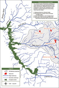
The combined waters of Santa Rosa and Matanzas creeks represent the largest subwatersheds of the system, but because a significant amount of water is detained in reservoirs, the contribution to the floodplain is greatly reduced from former times. These reservoirs include Matanzas Reservoir in Bennett Valley; Piner Reservoir on Paulin Creek, at the base of Hidden Valley; Brush Creek Reservoir, north of Badger Road; and Spring Lake, which receives peak flows from Santa Rosa and Spring creeks through diversion channels. Despite the tempering from these reservoirs, the channelized creek west of Willowside Road, still overflowed the tops of its levees, spilling water onto the agricultural fields to the north and south. In addition, water to the north of the creek’s levee flowed backwards, crossing Willowside Road and filling the hay field as far back as the Abramson Creek levee. Abramson Creek itself spilled water, through a local driveway bridge, onto the fields to the east, surrounding the levees with water on all sides.
Irwin Creek, the next minor creek south of Santa Rosa Creek, has a disproportionately large floodplain when compared to its contributing watershed area. Backwater from the Laguna created a 16-foot deep water body at the Sanford Road bridge, while extending its floodwaters 1.3 miles upstream. This surprising feature gives extra credibility to its nomenclature as “South arm of Sta. Rosa Cr” as shown on the 1853 US Surveyor General’s Plat Map Township 7 North Range 9 West. But in recent history, Irwin Creek does not have a sufficient collection basin to be considered a major contributor in its own right.
 Gravenstein Creek is also believed to be a former course—in geologic time—of the Santa Rosa–Matanzas watershed; however, in recent times much of Gravenstein’s upper watershed has been captured by Roseland Creek and shunted to reach the Laguna 0.6 miles south of its former course. Neither of these are considered major contributors to the floodplain.
Blucher Creek, the next creek south, is the only major source of water arriving from the west. The broad valley and undeveloped nature of the creek help to attenuate its flow, slowing the delivery of water to the Laguna over a greater period of time than most of the other creeks that pass through developed areas. Still, flood-waters reached higher than normal levels from Lone Pine Road to Todd Road. Extensive flooding of Todd Road, and the closure of Old Gravenstein Highway at Blucher Creek, are testament to its contribution to the floodplain. Todd Road at the corner of Powers Rd was under 5 feet of water, while Todd Road at the Blucher–Laguna confluence was under 10 feet of water.
 At the southern end of the floodplain, the combined waters of Gossage, Copeland and Bellevue-Wilfred joined to create a mega-flood: 565 acres of contiguous land were covered by the floodwaters east of Stony Point Road. The Bellevue-Wilfred Flood Control Channel was completely ineffective from Whistler Ave to the Laguna, a distance of 1.4 miles. Portions of the inundated hay fields on either side reached depths of four or five feet. The width of the flood waters (orthogonal to Bellevue-Wilfred) averaged 3900 feet.

