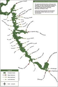
Waterway contributions
In order to understand the contribution of each waterway to the floodplain, I have classified them conceptually into three categories. Each waterway is classed according to its contribution of water to the floodplain during the December 31, 2005 flood. The classification scheme is tri-part: major, minor and local contributors. This scheme is based on personal observations of flood patterns from 1998–2008, and is provided here as a simple guide to readers who are not as familiar with the system. More rigorous schemes have been developed using modeling software, but they are only as good as actual observations, and they fail to convey the concept as simply.
 In the table below, the confluence waterway identifies the point of entry onto the floodplain, in most cases this is the Laguna or Mark West Creek or the “Laguna—Mark West complex”; Abramson Creek, Slusser, and the Russian River itself being the exceptions. The terminus is the mileage point (as measured in river miles from Jenner) where the water joins the confluence waterway. The headwaters is the highest point in the subwatershed with a well-defined channel. The length of the waterway (distance from headwaters to terminus) is reported as a simple surrogate for the subwatershed’s area.
Key:
* major contributor
# minor contributor
~ local contributor
Table: Waterways contributing to the floodplain
|
Waterway |
Confluence waterway |
Terminus |
Headwaters |
Length |
|
|
Russian River |
Pacific Ocean |
0.00 |
24.18 |
24.18 |
|
|
Castens |
Mark West Creek |
26.56 |
29.82 |
3.26 |
|
|
Windsor Creek |
Mark West Creek |
27.32 |
39.27 |
11.95 |
|
|
Slusser |
Windsor |
27.82 |
29.63 |
1.81 |
|
|
Historic Mark West |
Laguna – Mark West complex |
27.69 |
29.30 |
1.61 |
|
|
Clark |
Laguna – Mark West complex |
29.19 |
30.28 |
1.09 |
|
|
Vine Hill Creek |
Laguna – Mark West complex |
30.23 |
32.61 |
2.38 |
|
|
Atkinson |
Laguna – Mark West complex |
30.45 |
32.58 |
2.13 |
|
|
Bailiff |
Laguna – Mark West complex |
30.65 |
31.85 |
1.20 |
|
|
Illingsworth |
Laguna – Mark West complex |
31.05 |
33.98 |
2.93 |
|
|
Rued |
Laguna – Mark West complex |
31.90 |
33.21 |
1.31 |
|
|
Woolsey Creek |
Laguna – Mark West complex |
32.42 |
35.30 |
2.88 |
|
|
Mark West Creek (2008 configuration) |
Laguna |
30.38 |
56.04 |
25.66 |
|
|
Santa Rosa – Matanzas |
Laguna |
31.17 |
52.85 |
21.68 |
|
|
Abramson Creek |
Santa Rosa Creek |
32.99 |
36.99 |
4.00 |
|
|
Frei |
Laguna |
31.79 |
33.32 |
1.53 |
|
|
Smith |
Laguna |
31.84 |
32.91 |
1.07 |
|
|
Barcaglia |
Laguna |
32.87 |
33.59 |
0.72 |
|
|
Irwin Creek |
Laguna |
33.16 |
37.04 |
3.88 |
|
|
Jerusalem |
Laguna |
33.62 |
34.13 |
0.51 |
|
|
Pine Tree |
Laguna |
34.23 |
35.13 |
0.90 |
|
|
Zimpher |
Laguna |
35.47 |
36.55 |
1.08 |
|
|
Calder |
Laguna |
35.69 |
36.97 |
1.28 |
|
|
Gravenstein Creek |
Laguna |
36.40 |
40.08 |
3.68 |
|
|
Windmill |
Laguna |
36.78 |
38.85 |
2.07 |
|
|
Roseland Creek |
Laguna |
36.97 |
44.50 |
7.53 |
|
|
Walker |
Laguna |
37.45 |
39.81 |
2.36 |
|
|
Blucher Creek |
Laguna |
38.86 |
45.00 |
6.14 |
|
|
Colgan Creek |
Laguna |
39.26 |
47.35 |
8.09 |
|
|
Turner |
Laguna |
40.07 |
43.44 |
3.37 |
|
|
Bellevue-Wilfred |
Laguna |
42.31 |
49.27 |
6.96 |
|
|
Hinebaugh Creek |
Laguna |
42.79 |
48.30 |
5.51 |
|
|
Gossage Creek |
Laguna |
42.82 |
49.09 |
6.27 |
|
|
Copeland Creek |
Laguna |
43.57 |
52.84 |
9.27 |
|
|
Laguna headwaters |
Laguna |
43.57 |
46.70 |
3.13 |

